LA River Path
The project works to create a safe and efficient active transportation travel option by closing the largest continuous gap in the LA River Path network. This project will connect the San Fernando Valley with the Long Beach paths, and the communities in between.


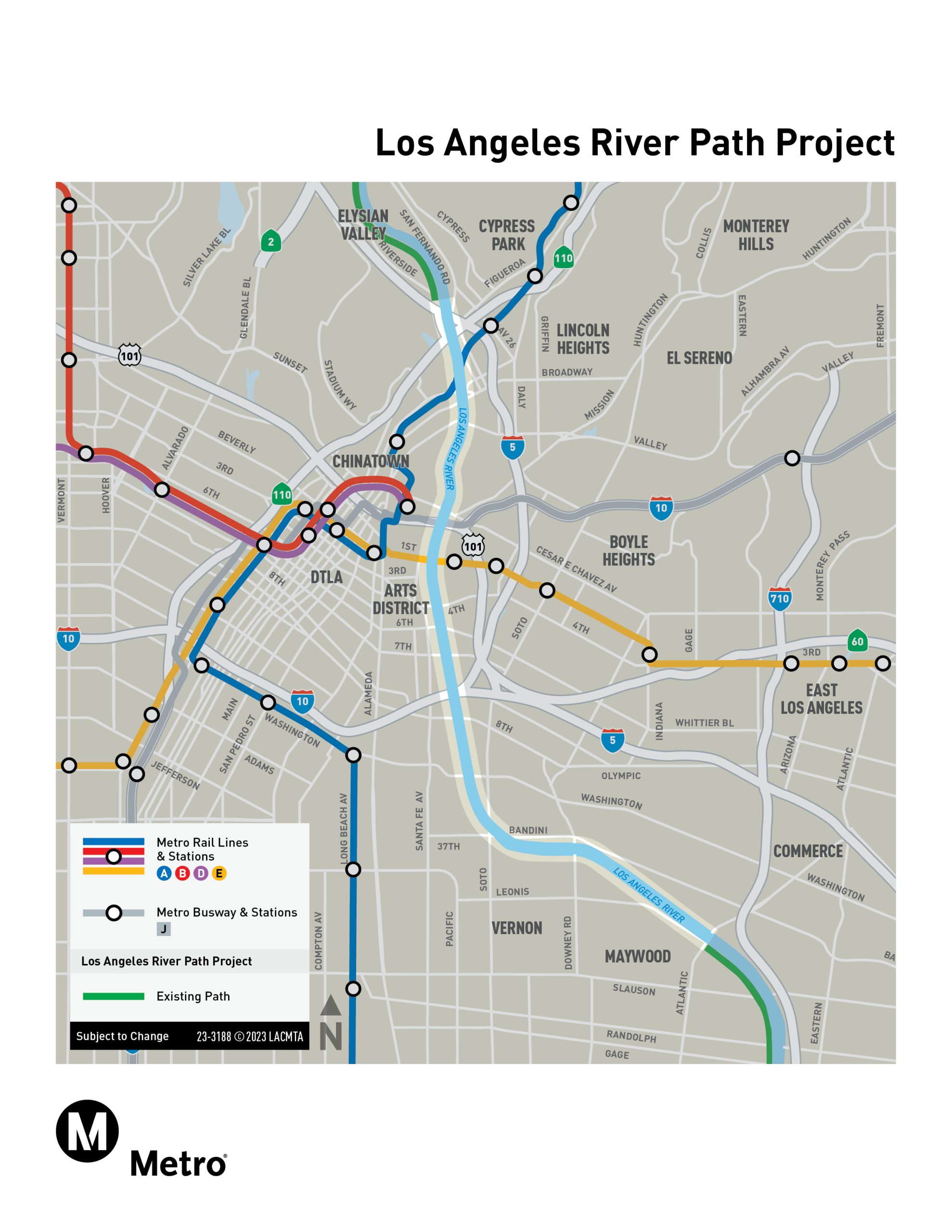
The LA River Path Project will complete an eight-mile active transportation corridor between Elysian Valley and the City of Maywood, closing the largest remaining gap in the LA River Path network. The new path will provide a continuous, grade-separated space for walking, biking, and rolling, connecting the San Fernando Valley to Long Beach.
Metro released a Draft Environmental Impact Report (EIR) in December 2025 for the LA River Path project in accordance with the California Environmental Quality Act (CEQA). The Draft EIR describes the Proposed Project and alternatives under study and evaluates potential environmental impacts. During the review period, the public had the opportunity to comment on the Draft EIR and to attend virtual and in-person public hearings.
Based on technical evaluations and comments received from the community and key agency stakeholders during the Draft EIR public review period, Metro developed a locally preferred alternative (LPA) for the project. The LPA mostly follows the Option 2 Alternative studied in the Draft EIR, combined with segments from two other Draft EIR Alternatives. This new alignment, Modified Option 2 will close the existing 8-mile gap and include 3 new river crossings and provide 10 new access points (7 on the east bank and 3 on the west bank). Metro also recommends a phasing plan with two initial operating segments of 5.5 miles, which build the northern and southern segments of the path, and leverage the City of LA's existing and planned on-street protected bike lane network to provide a safe connection through the Downtown area for cyclists of all ages and abilities.
Metro considered a bottom-of-channel path during the Conceptual Design phase but did not carry it forward as an alternative for detailed environmental study. As such, the bottom-of-channel path was considered and rejected in the Draft EIR, because it does not meet the project’s objectives for safety, access, and sustainable and efficient mobility.
A path located at the bottom of the river channel would be subject to closures during flood events, which could affect the reliability and year-round availability of the path. The location would also create challenges for emergency access, connections to surrounding neighborhoods, lighting and other amenities, and ongoing construction and maintenance. In addition, providing access from surrounding streets to a path at the bottom of the channel would require ramps that could be longer and steeper in some locations. These considerations, along with the extensive permitting and coordination required to construct and maintain a path within the channel, led Metro to focus the alternatives on path types located above the channel bottom including top-of-bank and incised paths where feasible.
The recommended Locally Preferred Alternative, Modified Option 2, prioritizes these path types to support a safer, more reliable, and more connected walking and bicycling route while reducing cost and permitting complexity.
Metro is leading the development of the LA River Path Project through the environmental review phase and has engaged communities along the LA River, including Elysian Valley, Cypress Park, Lincoln Heights, Chinatown, the Arts District, Boyle Heights, East Los Angeles, Maywood, and Vernon. Additionally, Metro is working with other stakeholders whose jurisdiction includes the LA River, to identify an operator and maintenance lead for the future project.

The project aims to accomplish the following goals:
- Providing, to the extent feasible, a seamless pedestrian and bicycling path between the San Fernando Valley in Los Angeles and the LA River Bicycle Path in Long Beach
- Improve safety for pedestrians and bicyclists from existing conditions.
- Increase access from local neighborhoods to employment centers, regional destinations, resources and amenities, including healthcare services.
- Reduce vehicle miles traveled by allowing people to walk and bicycle on a dedicated, vehicle-separated path through and within LA County, thereby reducing trip lengths and expanding travel choices.
- Improve access to opportunity for historically underinvested communities, especially in low-income and minority communities.
- Create a path that feels safe, comfortable and is a world-class transportation corridor open to people of all ages and abilities.
- Create a path that meets the needs of both recreational and everyday users and commuters.
Metro released a Draft Environmental Impact Report (EIR) in December 2025 for the LA River Path project pursuant to the California Environmental Quality Act (CEQA). During the 47-day review period, Metro hosted public hearings to present the Draft EIR and solicit public comments. Over 400 comments were received from agencies, organizations, and members of the public. The project team is currently reviewing all comments provided during the Draft EIR review period.
|
Path Design Elements |
Modified Option 2 |
|
|
|
|
|
|
|
|
Total Length of Path (miles)* |
10 |
|
|
|
|
|
|
|
|
Number of Access Points |
10 |
|
|
|
|
|
|
|
|
Access Points (East Bank/West Bank) |
||||||||
|
Ed P. Reyes River Greenway |
East |
|
|
|
|
|
|
|
|
LA State Historic Park |
|
|
|
|
|
|
|
|
|
Broadway / Spring |
East |
|
|
|
|
|
|
|
|
Albion Park |
East |
|
|
|
|
|
|
|
|
Mission Road / Cesar Chavez Av |
East |
|
|
|
|
|
|
|
|
Union Station |
West |
|
|
|
|
|
|
|
|
First St |
East |
|
|
|
|
|
|
|
|
Sixth St |
West |
|
|
|
|
|
|
|
|
Seventh St |
|
|
|
|
|
|
|
|
|
Washington Bl |
West |
|
|
|
|
|
|
|
|
Bandini-Soto Triangle |
|
|
|
|
|
|
|
|
|
Downey Rd |
East |
|
|
|
|
|
|
|
|
Atlantic Bl (new) |
East |
|
|
|
|
|
|
|
|
Number of River Crossings |
3 |
|
|
|
|
|
|
|
*Approximate Length of Path varies due to configurations for each alternative.


Access points are areas where users can enter and exit the LA River Path. The access points connect path users to the neighborhoods along the LA River as well as connecting them to job centers, schools, transit, parks and local businesses. Access points along the project may also offer amenities such as seating, wayfinding, and landscaping.
Metro considered a bottom-of-channel path during the Conceptual Design phase but did not carry it forward as an alternative for detailed environmental study. As such, the bottom-of-channel path was considered and rejected in the Draft EIR because it does not meet the project’s objectives for safety, access, and sustainable and efficient mobility.
The Draft EIR “Section 5.3 Alternatives Considered and Rejected” discusses the reasons why the Bottom-of-Channel alternative was considered and rejected.
The three factors to eliminate an alternative for further study into an EIR are:
- Failure to Meet Project Objectives: The BOC path type compromises equity and user experience, poses safety risks, and fails ADA compliance across all ages/abilities, introduces flood hazards, frequent path closures, and site constraints for standard amenities (lighting, signage). It’s also worth noting that the US Army Corps of Engineers’ regulations advise against entering the river channel for 72 hours after any rain event.
- Unavoidable Environmental Impacts: The BOC path type is likely to increase hydrological risks, alongside significant impacts on soil/geology and noise/vibration during construction.
- Implementation & Permitting Infeasibility: The BOC path type will encounter substantial agency permitting issues, requiring complex risk/safety studies and frequent US Army Corps of Engineers’ permitting for post-storm damage repairs.
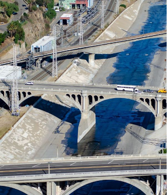
Through Metro’s project area (Riverside Drive to Atlantic Boulevard) the LA River channel is between 300 and 600 feet wide and around 30 feet deep. Within 24 hours after a typical storm begins, floodwater can reach a depth of 3 to 6 feet in the river channel and reach velocities up to and over 24 miles per hour, posing an immense threat to life and property that comes in its way. From a public safety and design perspective, the BOC makes it challenging for emergency response, liability and maintenance.
Get Involved
Help shape this project for good. We want to hear from you:
Got questions or ideas? Our project team is here to listen.
Our team is here to support your questions and help you understand what this work means for your community. We welcome your questions and ideas as we explore early concepts and community priorities.
Channels are monitored to make sure you receive timely support.